Easting Deeds
ShippingRecorded deeds become parcel geometry you can defend in a plat room.
- Who it's for
- County GIS and assessor offices, title and land-services firms, ROW teams
- Role in the roadmap
- Fast-to-market wedge
The work this replaces
A metes-and-bounds deed describes a parcel in prose: a point of beginning, then a run of courses with bearings and distances, sometimes curves, sometimes a “save and except” carve-out. Turning one into geometry means reading it carefully, keying every call, computing the traverse, and checking whether it closes. Thirty to sixty minutes for a clean deed. Longer for a 1975 photostat.
The accuracy bar is not cosmetic. Acreage sets tax assessments. Buffers determine who gets legal notice. A digitized parcel that is quietly wrong is worse than no parcel at all. If you currently do this with a desktop deed plotter, there’s an honest comparison of the tools, theirs and ours.
How it works
Extraction. A vision model reads the document and returns every boundary call as structured data: quadrant, degrees, minutes, seconds, distance, and the verbatim text it read them from. Uncertain digits get flagged rather than guessed.
Deterministic validation. Nothing is trusted on the model’s word. Software recomputes the traverse from the extracted calls, closes the figure, and compares the computed area against the acreage the deed states, in the document’s own unit, whether that is feet, meters, varas, or Gunter’s chains. Curve calls are handled, not skipped. GroundTruth has the full account of the checks.
A verdict, with reasons. Every tract comes back PASS, REVIEW, or FAIL. PASS means the traverse closes and the acreage corroborates. REVIEW spells out what disagrees: a misclosure of 2.21 feet over an 1140-foot perimeter, an acreage 4.7% off what the deed claims. FAIL means the description cannot be traversed as written, which happens more often than you would like.
Placement. A metes-and-bounds deed defines shape, not location: click the point of beginning, adjust rotation, and the parcel lands as a polygon plus a per-course line layer, each call with its bearing, distance, confidence, adjoiner, and source text. A PLSS aliquot deed places at its section with one click, and a composite conveyance places as a group from one click on its common commencement monument. Exports are GeoPackage, DXF for the CAD side (unplaced, since a deed describes shape rather than location), and the signed certificate.
How you get it
Three surfaces, one account. Pick where you work:
- In the browser. Sign up at app.easting.ai/signup: three documents free, no card, and your key is shown once. Nothing to install.
- In QGIS. The plugin is listed in the official QGIS plugin repository: Plugins → Manage and Install, search for “Easting”, paste your key into the plugin’s settings.
- Through the API. The developers page has the quickstart and api.easting.ai/redoc is the reference. Every account includes a test key that bills nothing.
One account covers all three: same key, same quota, and the same exports wherever you work. The user guide walks every step from sign-in through export, screenshots included. Questions first? sales@easting.ai answers.
For land teams
If you assemble rights for energy or infrastructure projects, recorded easements and rights of way are a document class, not an afterthought. Upload the instrument and you get what it burdens the land with: easement type, width where the document states one, term, exclusivity, the rights granted, and the parcel encumbered, each with its verbatim source text.
The honest part is what happens next. Most recorded easements do not locate their own area. The geometry sits on an attached drawing, or the centerline follows facilities the utility has not built yet, or the grant simply covers the whole property. Easting says so, names which case it is, and declines to draw a boundary the document never described. The easements that do carry courses are verified like any other traverse, closure and area both, and small ones are checked against stated square footage because rounded acreage cannot resolve a two-hundred-square-foot strip.
Deeds, PLSS aliquot descriptions, and the recording references and plat citations a deed carries all work the same way. If your work is measured in parcels per project rather than documents per month, there is a fuller account of what this handles, what it refuses to draw, and how the easement corpus was built on Easting for land teams, including project pricing and an honest comparison against buying seats.
What it does not do
Easement areas that exist only on an attached drawing are reported as unverifiable rather than traced; reading linework off a drawing is plat work, not deed work. Lot-and-block conveyances are captured as plat references (subdivision, lot, block, plat book and page), not drawn: plat linework is limited by the resolution counties publish. Metes-and-bounds placement is manual, not snapped to a parcel layer; PLSS aliquot tracts (“the SE 1/4 of the SW 1/4 of Section 9”) place themselves, georeferenced from BLM’s public survey fabric.
Recorded plats and utility as-builts are identified and classified rather than traced. A plat comes back with its subdivision, lots, blocks, recording, and surveyor; an as-built with its agency, utility, vintage, stationing, and pipe schedule. When a plat prints its boundary as tables (curve tables and line tables whose bearings are text), a second pass reads those tables at native resolution and the result faces the same closure gate a deed does: the traverse either closes and corroborates the sheet’s stated area, or the tract says why it doesn’t. Nothing is ever measured off the drawn linework, and a sheet whose printed values can’t be read with certainty refuses rather than guesses. An as-built states no coordinate basis, so it never reports a placeable boundary at all. That honesty is the feature. The corpus behind it spans 1913 to 2022 across five agencies, including sheets chosen because they should be refused.
Pricing
Introductory, and honest about being early:
- $10 per seat per month: the browser app, the QGIS plugin, and the hosted API, with 50 documents a month included per seat, then $0.40 per document.
- $30 once, for 10 documents: the document pack, for planners, consultants, appraisers, and anyone who meets a legal description a few times a year rather than monthly. Credits never expire, each extraction is itemized for pass-through billing, and failed extractions never spend a credit. Buy a pack and the key arrives on the next page.
- Government and on-premises: annual, talk to us. Air-gapped deployment is possible because the validation engine has no external dependencies.
- $0.50 per document, metered: no seats and nothing included, billed monthly from usage. The API-first shape; the developers page has the volume ladder.
Documents are never stored by Easting after extraction, on any plan. Results are kept until you delete them: your run history lists everything the account has run, and one button clears a result while another clears the lot. Nothing expires on a clock, and deleting leaves the record that the work happened, because your invoice refers to it.
Where you place a parcel is saved with it, so reopening a deed draws it back where you put it, in QGIS or in the browser. That position sits beside the extraction rather than inside it: a verdict is arithmetic we performed and can defend, and where a parcel meets the ground is your call.
What it looks like
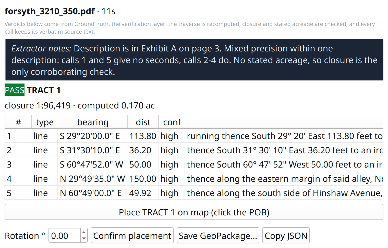
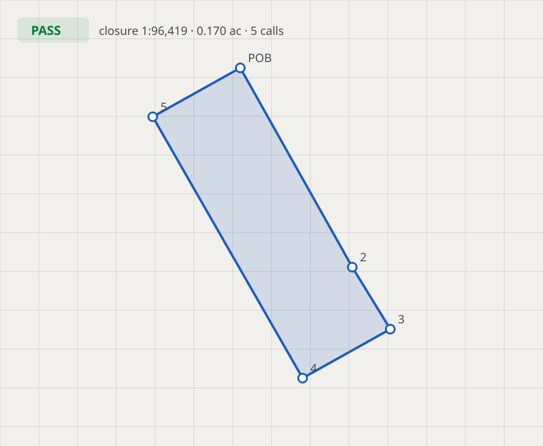
Screenshots show the QGIS plugin. The browser app at app.easting.ai presents the same review panel and map placement.
What it costs
Standard
$10 per seat / month
- Browser app, QGIS plugin, and hosted API
- 50 documents a month included per seat, pooled, then $0.40 per document
- Start free: 3 documents, no card
$10/month · 50 documents/month pooled
Document pack
$30 once / 10 documents
- Credits never expire — for planners, appraisers, and consultants who read a few deeds a year
- Each extraction itemized, ready to pass through to a client
- Failed extractions never spend a credit
$30 once · 10 documents, never expire
Start free takes no card: three documents that never expire, in exchange for your email, company and role. When they run out, a seat or a pack picks up where they stopped, and nothing charges you until you choose one. The document pack is a one-time payment: no subscription, nothing to cancel, and buying another later mints a fresh key. Checkout is Stripe; the API key is shown once on the claim page, and a sign-in invitation for app.easting.ai arrives by email. API-only volume runs metered at $0.50 per document with no seats — see the API page. Government and on-premises deployment runs annual — talk to us. Introductory pricing while the product is early.
Not sure it fits your documents? Send a sample and we'll run it before you subscribe.